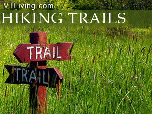
Southern Vermont Hikes
Equinox Stratton Bromley Green Mountain Nat. Forest Hiking Trails
 If your outdoor interests are piqued by the prospect of hiking a diverse trail system over varied terrain, encountering panoramic vistas, breathing fresh mountain air, splashing in brisk alpine streams, and resting in forests abundant with wildlife, then you have found your outdoor paradise in the mountains and woodlands of Southern Vermont. Yes, Vermont is a wonderful place to hike and explore. Please share your Vermont hikes and comments. To feature your VT business, contact us. Safe and happy hiking from Vermont Living Magazine.
Southern Vermont Hikes & Trails

West Mountain Inn, River Road, Arlington, VT 05250 | 802-375-6516
Nestled on a mountainside, the century old, seven gabled West Mountain Inn invites guests to discover its many treasures. Distinctively decorated guest rooms, comfortable common areas, 150 woodland acres with wildflowers, a bird sanctuary, and llamas. Miles of wilderness ski or hiking trails and the Battenkill River provide seasonal outdoor activities. Private dining and meeting rooms, A unique space for celebrations of weddings, birthdays, anniversaries, family reunions, or business meetings.
Visit West Mountain Inn - Arlington

Stratton Mountain Resort Long Trail House, Stratton, Vermont
Experience the true authentic Vermont beauty of Boyden Farm. Our 1900�s historic hayloft barn, open farmland and mountain views are the perfect setting for your wedding or corporate event. Reservations include onsite amenities; pricing based on hourly, midweek or weekend rates and availability. .
Stratton Mountain Resort Long Trail House - Stratton, VT

Mount Snow Vacation Rental Home, Wardsboro, VT
A very special place. A secluded Vermont vacation rental on 140 acres of land. Escape to a serene mountain haven where nature meets comfort. Find peace in the wooded surroundings and enjoy scenic golfing, world-class mountain biking nearby. Find current specials and rates below.
Visit Mount Snow Vacation Rental Home - Wardsboro, VT
 Haystack Trail (Haystack Mountain) – Wilmington, Vermont
Total Distance: 4.8 Miles
Hiking Time: 3 Hours
Vertical Rise: 1020 ft.
Rating: Moderate
In the Green Mountain National Forest
Care is needed to find the trailhead, located in the Chimney Hills development Northwest of Wilmington. From the Wilmington traffic light drive 1.1 miles west on Rt. 9, turn right on Haystack Rd. and at 1.4 miles bear right, continuing to follow the paved Haystack Rd. another 2.35 miles to an intersection. Turn left and follow the sign for Clubhouse and Chimney Hill Rd. At next intersection (2.5 miles) turn right on dirt road – Binney Brook Rd. Bear left at the next three intersections. At 3.5 miles, turn right on Upper Dam Rd. Continue for a short distance on this road to a left turn at 3.6 miles. At 3.8 miles you reach the trailhead, marked on your right with an orange arrow pointing up the trail. The trial follows an old road on easy to moderate grades marked sporadically with blue plastic diamonds to the 0.75 mile mark where it leaves the road and heads to Crystal and Haystack Ponds and the Deerfield Ridge Trail where it climbs more gradually along the ridge. The trail descends to pass between two rock outcrops before the intersection of Haystack Trail, which you follow to the 2.2 mile mark to bear left at another junction which you follow to the wooded summit at 2.4 miles. Your return hike follows the same trails back to the parking area.
Prospect Rock (Lye Brook Wilderness) – Manchester, Vermont
Total Distance: 3.0 Miles
Hiking Time: 2.5 Hours
Vertical Rise: 1100 ft.
Rating: Strenuous
In the Green Mountain National Forest
From the junction of Routes 11/30 and Route 7, a mile East of Manchester, drive East on Route 11/30 for 0.5 miles to East Manchester Road turning right for 150 feet, then left on Rootville Road for 0.5 mile to the white water tower and small parking area near a gravel driveway and house. Do not block the road and do not park near or past the ‘No Parking” signs.
The trail begins up the Old Rootville Road to a National Forest signboard where it continues past a spur trail and small brook before ascending steeply up the mountain, then levels off through the forest and climbs again with a steep drop-off on the right, before coming to the junction at 1.5 miles with Long Trail. Continue past Long Trail to a spur trail that leads 200 feet West to Prospect Rock. Your return hike follows the same trail back to the parking area.
Burr & Burton Trail (Equinox Mountain) –Manchester, Vermont
Total Distance: 5.8 Miles
Hiking Time: 5 Hours
Vertical Rise: 2880 ft.
Rating: Strenuous
In the Green Mountain National Forest
The trial is accessed through the Burr and Burton Seminary parking lot on Seminary Avenue in Manchester Village. The trailhead is located behind the school across the athletic field. This steep and demanding trail begins on an old logging road with a short detour to Lookout Rock with panoramic valley views, and continues up Equinox Mountain, the highest peak in the Taconic Mountain Range offering excellent views of New York State, the Berkshires and the Green Mountains. Your return hike will follow the same trail back to the parking lot.
Stratton Mountain Trail (Stratton Mountain) – Stratton, Vermont
Total Distance: 9 Mile Loop
Hiking Time: 7 Hours
Vertical Rise: 1910 ft.
Rating: Moderately Strenuous
In the Green Mountain National Forest
Follow Route 100 to the junction with Wardsboro-Arlington Road (or Kelley Stand Road) in West Wardsboro. Drive 7.1 miles West to the Long Trail parking area on the North side of the road. The trailhead is marked with a USFS sign.
Your hike begins North along the white-blazed Long Trail up the bank behind the parking area, and continues from there intersecting old logging roads, wet areas, and an historic farm site to gate of USFS Road – FR 341 at 1.3 mile mark (note this junction for your return hike). From here the trail ascends more steeply over varied and uneven terrain to the Stratton Mountain Trail at the 2.5 mile mark an on to an overlook and the fire tower at 3.4 miles. You can return from here following the same trail back down, or continue North on the Long Trail along the summit ridge to another over look before descending steeply at 4.0 miles over rugged terrain until the trail moderates and intersects again with USFS FR-341 at 5.1 miles, where you turn left and follow the USFS road to the Long Trail intersection at 7.6 miles, which you noted at the beginning of your hike. Follow the Long Trail South back to the parking area.
Bald Mountain Trail ( Bald Mountain) – Townshend, Vermont
Total Distance: 3.5 Mile Loop
Hiking Time: 3 Hours
Vertical Rise: 1100 ft.
Rating: Moderate Ascent / Strenuous Descent
In the Townshend Sate Forest
From Townshend follow Route 30 2.0 miles North to the Townshend Dam, turning West across the spillway to a ‘T’ where you turn left and pass the Scott Covered Bridge, to bear right and travel parallel to the West River to the State Park entrance at 1.4 miles. Cross the road to the right of the Park building to campsite #25 where the trailhead is marked with a sign and very large blue blazes. The trail criss-crosses a brook to the 0.6 mile mark where it bears right and ascends over varied terrain up a hillside to the 1680 foot summit at 1.7 miles. From the summit take the blue-blazed trail to the right of the northern overlook, which rapidly descends and bears right at 2.0 miles down a steep hill with occasional views. The downgrade continues to the 3.3 mile mark where it eases leading to campsite #6 of the campground. Follow this road back to the parking area.
Bromley Mountain Trail (Bromley Mountain) – Peru, Vermont
Total Distance: 5.6 Miles
Hiking Time: 5 Hours
Vertical Rise: 1460 ft.
Rating: Moderate – Strenuous
In the Hapgood State Forest
The trailhead parking area is located on Route 11 midway between Peru and Manchester Center. This trail follows moderately rugged terrain along a portion of the Appalachian National Scenic Trail and Long Trail through the Hapgood State Forest. At 2.5 miles it links to a ski trial leading to panoramic views at the summit. Your return hike can follow the same trail back to the parking area on Route 11, or continue on descending steeply before reaching a spur trail leading to FR 21 on the other side of Bromley Mountain.

inns | hotels | resorts | rentals | attractions | dining | real estate
SUGGESTED SOUTHERN VT LODGING Visit Southern VT Vacation Specials. Browse Manchester VT area vacation rentals, inns, resorts, and pet-friendly lodging availabilities below.Vermont Hiking Trails
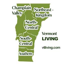
Explore Vermont hiking trails in every region. Champlain Valley, Northeast Kingdom, North-Central, South-Central and Southern Vermont.
Champlain Valley VT Hikes & Trails
Burlington, Middlebury, St. Albans, the Islands of NW Vermont
North Central VT Hikes & Trails
Montpelier, Barre, Randolph, Waterbury, Stowe, Mad River Valley
Northeast Kingdom VT Hikes & Trails
St. Johnsbury, Newport, Barton, Lyndonville, Burke, Jay, Island Pond
South Central VT Hikes & Trails
Rutland, White River Jct., Woodstock, Quechee, Brandon, Killington, Ludlow, Weston, Chester
Southern VT Hikes & Trails
Bennington, Brattleboro, Manchester, Arlington, Newfane, Mt. Snow area
Hiking Tips | Wiessner Woods Stowe Hikes
Vermont Products | Visit VT Towns and Cities | FWM 24/7 Shopping
Country Weddings | New England Recipes | VT Inns
New England Living Magazine
Fitness and Sports Products On Sale Now
Join Amazon Prime - Watch Thousands of Movies & TV Shows Anytime - Start Free Trial Now
Free World Mall
Country Weddings | Vermont Products | New England